|
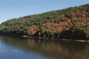
Gruža Location | 23km southwest of the city of Kragujevac | State | Srbija | Latitude | 43° 57’ N | Longitude | 20° 35,8’ E | Altitude | 238-269m |
 Surface area [ha] | 934 | Volume [m3] | 64,4 x 10⁶ | Maximum depth [m] | 31 | Water level control | unregulated | Normal range of annual water level fluctuation [m] | 3-5 | Length of shoreline [m] | - | Residence time [yr] | 2 | Catchment area [ha] | 318,2 | Hours of bright Sunshine [hr yr-1] | 318,2 | Solar radiation [MJ m-2 day-1] | | Freezing period | | Mixing type | dimictic |
Annual fish catch [t yr-1] Total N loading [t yr-1] | - | Total P loading [t yr-1] | - | Population | - | Population density of
catchment area [person km-2] | 45/km2 |
WATER USAGE Domestic water usage [m3 sec-1] | - | Irigation water usage
[m3 sec-1] | - | Industrial water usage
[m3 sec-1] | - | Power generation usage [m3 sec-1] | - |
LAND USE LIMNOLOGICAL RESEARCH | Intervention in the reservoir | Physical and chemical features | Zooplankton | Phytoplankton | Microbial community 1. THE COMPOSITION AND DYNAMICS OF MICROBIAL COMMUNITY IN THR GRUŽA RESERVOIR 2. A MICROBIOLOGICAL INDEX IN ESTIMATION OF SURFACE WATER QUALITY (mWQI) | Macrozoobentos | Entomofauna | Macrophytes | Ichthyofauna 1. THE ICHTHYOFAUNA OF THE GRUŽA RESERVOIR 2. THE ICHTHYOFAUNA OF THE GRUŽA RIVER AND RESERVOIR GRUŽA | Fungal community | Trophic condition | Quality of water | Estimate of the effectiveness of methods used to improve the quality of water in the Gruza reservoir | Sources of data |
|
